

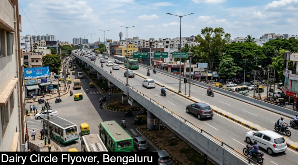
The Dairy Circle flyover carries traffic over the Dairy Circle junction in south-central Bengaluru, where Hosur Road, Bannerghatta Road and the Lakkasandra and Wilson Garden side streets meet. The junction is named after a former Karnataka Milk Federation dairy and sits in the Lakkasandra and Wilson Garden area (PIN 560030), a few kilometres south of the city centre.
It matters because it links the old city and Jayanagar with Koramangala, Silk Board and the Electronic City corridor. Peak traffic is heavy, roughly 8:30–10:30 AM and 5:30–9:00 PM, so plan around those hours.
I could not find a reliable source for the flyover’s length or opening year, so the guide leaves those out rather than guess.
Directions
Distances and times below are approximate, taken from a travel guide, and swing widely with traffic. Check a live map before you leave.
| From | Approx. distance | Approx. time | Route notes |
|---|---|---|---|
| MG Road | 8–10 km | 25–40 min | South via Richmond Road and Hosur Road |
| Koramangala | 5–7 km | 15–25 min | Hosur Road or Outer Ring Road |
| Silk Board | 6–8 km | Varies | North along Hosur Road |
| Electronic City | 12–14 km | 25–40 min | Hosur Road, or the elevated expressway for part of the way |
| Whitefield | 22–25 km | Varies | Outer Ring Road and Silk Board |
| Hebbal / Airport side | 20–25 km | Varies | Via central Bengaluru |
On arrival, local landmarks help: NIMHANS Hospital lies to the west, Silk Board and Christ University to the east, Bosch’s south campus to the north and Sri Jayadeva Institute of Cardiovascular Sciences to the south.
Connectivity
Roads. Hosur Road is part of National Highway 48 and links Bengaluru with Hosur. Dairy Circle sits at its junction with Bannerghatta Road, and the Outer Ring Road is nearby. Buses, app cabs and autos all serve the junction.
Metro. Dairy Circle will get its own underground station on the Pink Line, between Lakkasandra and Tavarekere. It is still under construction, with an opening around December 2026 that remains unconfirmed, and reports from late September 2026 point to further delays on the Pink Line. Treat any date as provisional until BMRCL announces it.
| Detail | Status |
|---|---|
| Station type | Underground, island platform |
| Line | Pink Line (Kalena Agrahara to Nagawara) |
| Neighbouring stations | Lakkasandra (towards Nagawara), Tavarekere (towards Kalena Agrahara) |
| Planned interchange | Red Line (under construction) |
| Builder | Afcons Infrastructure |
Once the Pink Line opens, riders can change at Jayadeva Hospital for the Yellow Line towards Electronic City and at MG Road for the Purple Line.
Nearby areas and what they offer
| Area | What it offers |
|---|---|
| Jayanagar | Established residential area with shopping; average prices about ₹18,900 per sq ft |
| Tavarekere | Next Pink Line stop south; about ₹19,300 per sq ft |
| Adugodi | Close by, with lower prices of about ₹11,700 per sq ft |
| Lakkasandra / Wilson Garden | Older neighbourhoods around the junction, near Lalbagh |
| Koramangala | Malls (Forum, Nexus), cafes and offices to the east |
| BTM Layout, JP Nagar | Residential areas reached via Bannerghatta Road |
| NIMHANS and Kidwai | Major hospitals nearby, including Kidwai Memorial Institute of Oncology and Prasad Eye Hospital |
Schools nearby include Christ School and Carmel Convent School. Property prices above are neighbourhood averages from Square Yards, since no figure is listed for Dairy Circle itself; the area is central but has many older buildings and limited new supply.
FAQ
Where is the Dairy Circle flyover?
It spans the Dairy Circle junction in Lakkasandra and Wilson Garden, where Hosur Road meets Bannerghatta Road in south-central Bengaluru.
Is there a metro station at Dairy Circle?
Not yet. An underground Pink Line station is under construction, with an opening around December 2026 that is still unconfirmed.
When is traffic worst?
Roughly 8:30–10:30 AM and 5:30–9:00 PM on weekdays.
How far is it from MG Road?
About 8–10 km, which takes around 25–40 minutes depending on traffic.
How far is it from Electronic City?
About 12–14 km, and the metro option will need a change at Jayadeva Hospital once the Pink Line opens.
Which hospitals are close?
NIMHANS, Kidwai Memorial Institute of Oncology, Prasad Eye Hospital and Sri Jayadeva Institute of Cardiovascular Sciences.
What is the length of the flyover?
I could not verify this from a reliable source; check with the Bruhat Bengaluru Mahanagara Palike or the traffic police.